Google Maps will show areas of polluted air. Know the way of discovering air quality at your location!
By using Google Maps, one can get an idea about the air quality of a particular area at home. For this, Google has added the ability to report air quality on Google Maps. Using this new facility, one can know the level of air pollution in a region before traveling. This information has been informed in a report of the technical website The Verge.
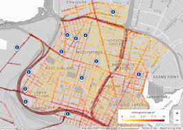
To know the level of air pollution, the air level map of the specific region can be seen directly on Google Maps. Google will create this map of the air level by using data from the United States Environmental Protection Agency EPA, air quality monitoring organization PurpleAirs and Brezhometer network sensors.
Apart from viewing the air level map of a specific region, by clicking on the dot on the map, you can also know about the harmful aspects of polluted air along with the time of updating the information. Initially, iOS and Android operating system users living in the United States will get access to air quality. This facility will be introduced in all countries gradually.
google air quality my location, air quality index, air quality in my location, air quality satellite map, air pollution map, air quality index today, aqi of my location, google earth